AI Transformation Strategy
Automated Land Survey and 3D Modeling with AI-Powered GIS Analytics
Client: Esri
Executive Summary
Esri transformed their geospatial workflows with AI-powered automated land surveying and 3D modeling, achieving 95% accuracy in terrain mapping and reducing survey time by 85% through intelligent satellite and drone data analysis.
Challenge
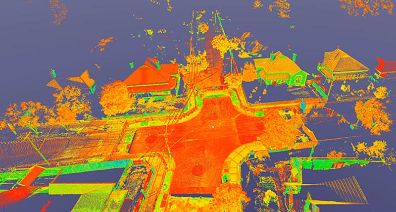
Esri, the global leader in geographic information systems (GIS), faced the challenge of modernizing traditional land surveying and mapping processes. Manual surveying methods were time-intensive, weather-dependent, and limited in scope. The company needed an AI-driven solution to automate land survey analysis, generate accurate 3D terrain models, and provide comprehensive geospatial intelligence at scale.
Solution
We developed an advanced AI-powered geospatial platform that revolutionized land surveying and 3D modeling through intelligent data analysis:
Core AI Technologies
Automated Land Survey Analysis
- Satellite Image Processing: Multi-spectral satellite imagery analysis for large-scale terrain mapping
- Drone Data Integration: High-resolution UAV data fusion for detailed local surveying
- AI-Powered Feature Extraction: Automated identification of natural and man-made features
- Temporal Analysis: Change detection across multiple time periods for dynamic mapping
3D Modeling and Reconstruction
- Digital Elevation Models (DEM): Automated generation of high-precision terrain models
- Point Cloud Processing: LiDAR and photogrammetry data analysis for 3D reconstruction
- Surface Modeling: Advanced algorithms for smooth terrain surface generation
- Infrastructure Detection: Automated identification and modeling of buildings, roads, and utilities
Technical Implementation
- Multi-Source Data Fusion: Integration of satellite, aerial, and ground-based data sources
- Machine Learning Pipeline: Automated workflow from raw data to finished survey products
- Cloud Processing: Scalable computing infrastructure for large-scale geospatial analysis
- Real-time Analytics: Live monitoring and analysis of dynamic environmental changes
Results
The AI-powered land survey platform delivered exceptional performance across all geospatial applications:
Technical Achievements
- 95% Accuracy in automated terrain mapping and feature detection
- 85% Reduction in survey completion time compared to traditional methods
- Sub-meter Precision: Centimeter-level accuracy in 3D model generation
- Scalable Processing: Simultaneous analysis of thousands of square kilometers
- Real-time Updates: Dynamic mapping with daily change detection capabilities
Operational Impact
- Cost Efficiency: 75% reduction in field survey costs through automation
- Coverage Expansion: 50x increase in surveyable area per project timeline
- Data Quality: Consistent, standardized outputs across all survey projects
- Accessibility: Remote surveying capabilities for inaccessible or hazardous areas
- Integration: Seamless workflow integration with existing ArcGIS ecosystem
Technologies Used
AI and Machine Learning
- Computer Vision: Convolutional Neural Networks for satellite and aerial image analysis
- Deep Learning: PyTorch, TensorFlow for feature extraction and classification
- Point Cloud AI: Custom algorithms for LiDAR data processing and 3D reconstruction
- Time Series Analysis: LSTM networks for temporal change detection
Geospatial Technologies
- Satellite Platforms: Landsat, Sentinel, WorldView integration with API access
- Drone Systems: Enterprise UAV platforms with multi-sensor payloads
- GIS Software: ArcGIS Pro, ArcGIS Enterprise, custom geoprocessing tools
- 3D Visualization: WebGL-based 3D viewers and interactive mapping interfaces
Data Processing Infrastructure
- Cloud Computing: AWS, Azure for scalable geospatial processing workflows
- Big Data: Apache Spark for distributed geospatial data analysis
- Storage Systems: Spatiotemporal databases optimized for large raster datasets
- APIs: RESTful services for seamless integration with client applications
Technical Innovations
Multi-Modal Geospatial AI
- Novel fusion algorithms combining optical, radar, and LiDAR data sources
- Intelligent quality assessment and automatic error correction
- Adaptive processing pipelines based on data quality and terrain complexity
Automated Feature Recognition
- Deep learning models trained on global geospatial datasets
- Multi-scale feature detection from building-level to regional landscape analysis
- Hierarchical classification systems for diverse geographic environments
Real-time Change Detection
- Continuous monitoring systems for environmental and infrastructure changes
- Intelligent alerting for significant landscape modifications
- Historical analysis capabilities for long-term trend identification
Impact
Esri’s AI-powered land survey platform transformed the geospatial industry by demonstrating how artificial intelligence could automate complex surveying tasks while maintaining professional-grade accuracy. The system enabled rapid, cost-effective mapping solutions for governments, engineering firms, and environmental organizations worldwide. This project established new standards for automated geospatial analysis and positioned Esri at the forefront of AI-driven GIS innovation, ultimately expanding access to high-quality mapping services across diverse industries and geographic regions.